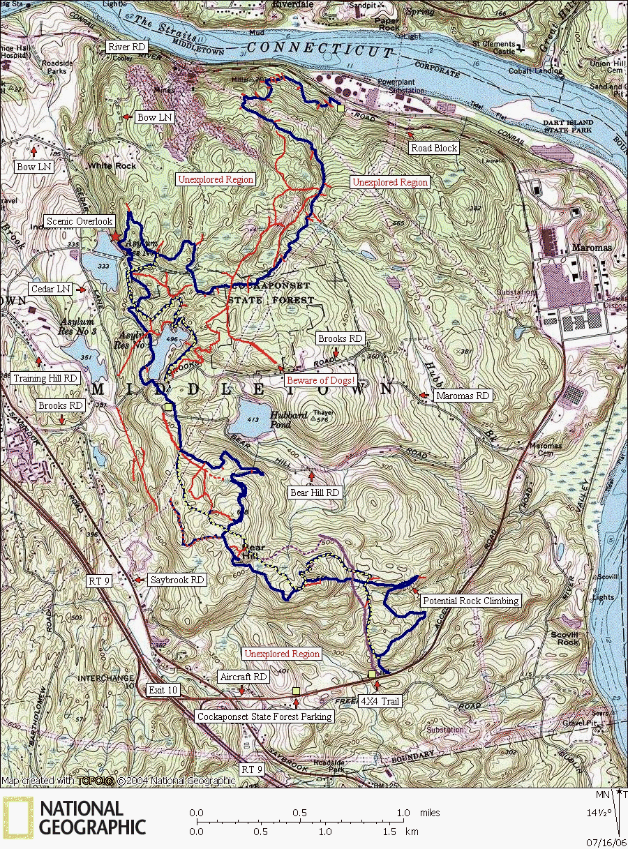
Middletown Area of Cockaponset
Ratings Explained: The ratings are based on mountain biking difficulty and may also translate to hiking and horseback riding difficulty in most cases. The ratings do not take into consideration how steep and strenuous the trails may be, only the difficulty of the traveling surface; 0 rated trails are smooth and easily traveled, X rated trails are on the lower end of technical difficulty with a few rocks and roots to maneuver around, XX rated trails are quite difficult requiring at least intermediate level skills to maneuver around very rocky and root infested sections with possible off canter balancing, and XXX rated trails are extremely difficult trails that are impossible for most mountain bikers excluding a few master riders.
The thin red trails represent unmarked trails while the short red stubs represent unexplored cross-trails. The purple trail, a 4X4 access road, is not marked with blazes. All other colored trails represent the color of the blaze.
The Middletown area of Cockaponset State Forest is surrounded by quasi-public land. Northeast Utilities manages a wildlife area with the help of the CT DEP. The power station along the Connecticut River is the trailhead for the Mattabesset Trail (blue), but putting in that extra mile or so to start from the river isn't worth the trip. The hiking from the river to about 1/2 mile to Reservoir 333 is extremely unscenic and riddled with renegade dirtbike cross-trails. The remainder of the area becomes rugged with large granite and quartz outcroppings. This makes for an exotic feel for both hiking (blue trail) and mountain biking (non-blue trails). The terrain is strangely similar to the famous Paha-Sapa trail in the Black Hills of South Dakota! For that reason, this may be the most enjoyable ride for seasoned mountain bikers.
Trail Descriptions:
Mattabesset Trail (blue): A hiking trail only. The extreme north end between reservoir 333 and the power plant is unscenic and not necessary to hike. The remainder of the trail is rugged and surrounded with large granite outcroppings.
Reservoir Loop Trail (blue/yellow): The north trail section is rated XX for quick turns through laurel forests and frequent obstacles. The south section of the trail is rated XX for exotic riding over difficult off-canter rock outcroppings.
Blue/Red Trail: This is a mountain biking trail with large natural stunt features over granite outcroppings. Most of the trail can be ridden with an X rating, but to enjoy the obstacles, riders should have XX or XXX ability.
The 4X4 Access Road: Marked in purple on the map, but the trail has no blazes. It is X rated with a few XX spots and makes for a fantastic downhill.
Unmarked Trails: Colored in red on the map. Most of these trails are XX with a few XXX spots. A tight ride through a mountain laurel forest is the red trail on the east side of reservoir 413. The trails braided around the Mattabesset south of Bear Hill RD are through exotic granite outcroppings.
www.nationalgeographic.com/topo
Map created with TOPO! copyright 2006 National Geographic
Trail data copyright 2006 CTXGuide.Com


